Views: 500 Author: Curry Publish Time: 2026-02-25 Origin: https://www.microductcoupler.com/


You can build a flawless fiber route and still get burned later if crews can't precisely relocate what they buried. Near surface markers(NSMs)—passive electronic markers and programmable EMS/RFID markers—give you reliable, point-accurate locations for microduct entries, handholes, splice closures, and repair sites.
What you'll learn here
Marker families (near-surface/disk, ball/self-leveling, programmable EMS/iD): how they work and when to use them.
Frequency and APWA color alignment for North America, with cross-brand notes and verification tips.
Realistic detection depths and what affects them.
Practical placement for telecom/fiber: microduct routes, drops/risers, handholes/splices, and repairs.
Procurement, AQL sampling, and acceptance testing checklists.
Mixed-ecosystem operations (3M, Radiodetection, Tempo/OmniMarker) and GIS/serialization workflows.
Marker families explained (and when to use each)
Near surface markers are resonant devices tuned to utility-specific frequencies. Some variants add memory so you can store a unique ID and attributes. Think of them as precise breadcrumbs you bury at the exact points you’ll need to find later.
Passive near-surface markers (flat/disk)
What they are: Shallow-placement, frequency-tuned markers used for pinpointing entries and changes above buried plant. Designed for ≤0.9–1.0 m burial.
When to use: Customer drops, aerial-to-underground risers, curb transitions, building entries, and shallow microduct crossings.
Why they work: A tuned coil resonates at the chosen frequency, giving a sharp peak with compatible locators.
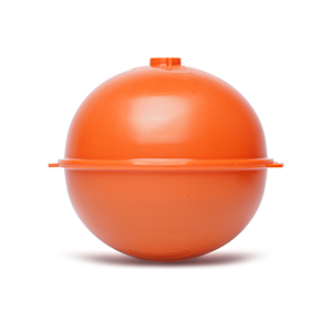
Ball/self-leveling or disk "extended range" markers
What they are: Spherical or disk markers that self-orient for a strong peak. Suitable around splice closures, handholes/manholes, and repairs where backfill depth is greater.
When to use: Splice cases inside handholes, manhole approaches, mid-span repairs, deeper backfill sections.
Detection class: Typically deeper reach than near-surface markers, but still frequency-specific.
Programmable EMS/iD markers (RFID-enabled)
What they are: Markers with readable/writable memory (unique ID, utility type, install date, notes). The physical locate is still by frequency; the data read/write needs a compatible reader.
When to use: Assets that need identity in GIS/EAM (e.g., splice closure IDs, handhole IDs, critical crossings) and where you want field crews to verify identity with a scan.
Operating principles and compatibility
Cross-brand locate: Passive detection is frequency-based. If your locator supports that frequency, it can detect the marker regardless of brand. This principle is reflected in manufacturer and CGA guidance; see the communications locating overview on 3M's site in the telecommunications locating and marking page and the Tempo OmniMarker brochure for frequency examples.
Programming boundary: Reading/writing iD memory generally requires the matching ecosystem (e.g., 3M Dynatel iD readers for 3M iD markers). You can still physically locate the marker with any locator that supports the frequency.
References for fundamentals: CGA explains electronic marker use in Best Practices 21.0, Practice 2.19, and 3M publishes a depth class table in the EMS Markers Technical Data Sheet (2024).
Frequencies and APWA colors (North America)
To avoid cross-talk and mis-identification, each utility type uses a unique EMS marker frequency. Surface paint and flags follow APWA colors so everyone reads the ground the same way.
APWA color alignment (surface marks):
Orange: communications (telephone, CATV, fiber)
Red: electric power
Yellow: gas, oil, steam
Blue: potable water
Green: sewer/drainage
Purple: reclaimed water/reuse
White: proposed excavation
Fluorescent pink: survey/unknown The mapping is defined in APWA's uniform color code summary.

Example frequency mapping (verify locally):
Communications/Telephone: around 101.4 kHz in many fleets
CATV: often 77 or 83 kHz (depends on ecosystem)
Gas: commonly 83 or 121.6 kHz
Water: commonly 145.7 kHz
Sewer: commonly 121.6 kHz
Power: commonly 169.8 kHz Manufacturer brochures (e.g., Tempo OmniMarker) and locator manuals (e.g., Radiodetection RD8100 Marker guide) enumerate supported marker frequencies; CGA's Appendix B describes selection examples by utility category.
Practical policy
Publish a site-specific frequency policy for your crews (e.g., telecom/telephone = 101.4 kHz; CATV = 83 kHz) and include it in pre-job briefs. Inventory your locators and confirm support for each chosen frequency.
Note on regions: Some international fleets use 134 kHz for power and other variants. Always check locator documentation and run a pilot.
Detection depths you can actually plan for with near surface markers
Vendor datasheets provide maximum detection/read depths under controlled conditions. In the field, soil, moisture, backfill, pavement, and operator technique all matter. Plan conservatively unless you’ve validated locally.
Benchmarks from manufacturer documentation
3M EMS Markers TDS (US locators) shows typical maximums:
Passive near-surface: up to 3 ft (0.9 m)
Passive ball: up to 6 ft (1.8 m)
Passive mid-range: up to 7 ft (2.1 m)
Passive full-range: up to 9 ft (2.7 m)
iD near-surface: up to 3 ft (0.9 m) read range
iD ball: up to 5 ft (1.5 m) read range
iD full-range: up to 8 ft (2.4 m) read range Source: 3M EMS Markers TDS (2024).
Tempo OmniMarker materials commonly cite detection up to about 5 ft (1.5 m) for passive ball/disk styles, dependent on soil and locator; see Tempo's brochure.
Conservative planning ranges (use until your pilot confirms higher)
Near-surface: 0.6–0.9 m
Ball/disk extended range: 1.5–1.8 m
Full-range classes: 2.1–2.4 m (if used in your ecosystem)
What reduces detection performance
Dry sandy soils or very low moisture content
Metallic clutter or rebar grids that create interference
Poor orientation (for non-self-leveling markers)
Thick pavement or depth beyond the class rating
Locator setup tips
Use the exact utility frequency and ensure you're in marker mode (not active line tracing).
Sweep in orthogonal passes to nail the peak and confirm with a null.
Log the measured depth and signal strength for QA and GIS notes.
Telecom/fiber placement patterns that work in the field
These patterns reflect how telecom/OSP teams place near surface markers to make future locates fast and unambiguous.
Microduct routes and bends
Place near-surface markers at significant changes: road crossings, 90° bends, and major junctions.
At long straight runs without other locatable plant, consider interval placement (e.g., 60–100 m) where local rules allow.
Drops and aerial-to-underground risers
Mark the exact riser/entry point, especially for MDUs and customer laterals that aren't metallic.
Use near-surface markers at shallow depth with APWA orange surface indication.
Handholes, splice closures, and repairs
Surround the splice case or the handhole location with a ball or extended-range disk marker buried per depth class.
For repair sites, place a marker directly above the repaired section and note the reason in GIS.
Documentation tips
Record marker UID (or programmed iD), frequency, APWA color, depth, and associated asset (microduct ID, splice ID).
Capture GNSS coordinates and at least one photo per location to tie the marker to visible context.
Supporting sources: CGA's Practice 2.19 endorses electronic markers for nondetectable facilities; manufacturers outline form-factor usage by depth and application in documents like 3M's telecom locating page.
Mixed-ecosystem playbook: interoperability and field validation
Interoperability principles
Physical locate is frequency-based and largely cross-brand; iD read/write is typically brand-specific.
Crews commonly run mixed fleets (3M Dynatel, Radiodetection MRX/RD8100, Tempo). Align frequencies to what every locator can detect.
Locator capability inventory (do this once per fleet)
List each locator model and supported marker frequencies (e.g., 77, 83, 101.4, 121.6, 145.7, 169.8 kHz).
Note which models can read/write iD markers and which can only detect. Radiodetection documents supported marker frequencies for the RD8100 series in the Marker user guide.
Field validation protocol (pilot before rollout)
Select representative sites (soil types, depths, pavement).
Bury test markers at known depths: near-surface class (~0.6–0.9 m) and ball/disk class (~1.2–1.8 m).
Test with at least two locator brands/models from your fleet.
For iD markers, attempt read/write of a test attribute.
Log depth readings, signal strength/quality, and time to locate.
Set pass/fail criteria (e.g., 95% detection success within 60 seconds at planned depth).
Publish the results as your local capability table.
Simple log fields to capture
Date/time, site/soil type, marker type, nominal depth, measured depth, frequency, locator model, detection success/time, iD read/write success, notes.
Documentation and references: See Radiodetection's marker locator guide for modes/frequencies and CGA Practice 2.19 for deployment guidance. 3M's iD workflows and depth classes are summarized in the EMS markers TDS.
Procurement and QA: what to specify, sample, and test
Specification language (copy/paste starters)
Utility frequencies: Provide markers tuned to the following frequencies (verify locally): communications/telephone 101.4 kHz; CATV 83 kHz; gas 83 or 121.6 kHz; water 145.7 kHz; sewer 121.6 kHz; power 169.8 kHz.
Examples of these frequencies appear in manufacturer literature such as Tempo OmniMarker.
Detection performance: State nominal maximum detection/read depth by marker class and provide installation orientation instructions. The buyer will plan to 60–80% of the nominal maximum unless a pilot confirms more. Depth classes are listed in 3M's EMS TDS.
Materials/environment: HDPE housings or equivalent corrosion-resistant enclosures; operating/storage temperatures suitable for local climate; ingress protection suitable for buried use.
Identification: For iD markers, provide unique serialized IDs and documentation of data schema and compatible readers.
Compatibility: Declare compatibility with the buyer's locator models (list exact models).
Incoming inspection and AQL sampling
Use ANSI/ASQ Z1.4 (ISO 2859-1) attribute sampling. Select AQLs (e.g., 0.65% critical, 1.5% major), determine the code letter by lot size, then sample per the table. See ASQ's Z1.4 overview for method basics.
Inspect labeling (utility/frequency), color coding, housing integrity, and serialization on iD models.
Bench test a sample with two different locators from the fleet at a controlled spacing (air test and soil bin), confirming frequency and signal response.
Arrival acceptance test checklist
Visual check: correct frequency marking, APWA color indication, intact housings.
Function test: detect/read at a fixed test distance; for iD, read UID and write/verify a test field.
Documentation: log serials/UIDs, lot numbers, test results, and photos in an acceptance form.
Guidance and references: CGA electronic marker guidance in Best Practices 21.0; 3M depth classes in the EMS TDS; and attribute sampling via ASQ Z1.4.
GIS and serialization: make markers first-class assets
Field attributes to capture
uid (marker serial or programmed ID)
marker_type (near-surface, ball, disk)
frequency_kHz
utility (aligned to APWA color domains)
depth_mm
install_date and installer_id
associated_asset_id (e.g., microduct_ID, splice_ID)
gps_method and horizontal_accuracy
photo_url/attachment
notes
Data model tips
Parent-child structure: store the marker as a point feature with permanent UID; store inspections/updates as related records so history isn't overwritten.
Offline readiness: define offline map areas, restrict layers to essentials, and enable attachments for photos.
Utility Network alignment: map markers to the correct feature classes and asset types, validating domains and associations before rollout.
Helpful resources: Esri outlines offline capture and related tables in Field Maps implementation guides and a Field Maps Q&A.
For example: telecom lateral at a handhole
Scenario
You're placing a fiber lateral into a handhole on a residential street. Backfill depth near the entry is ~0.7 m; the splice case sits deeper at ~1.3 m.
Steps
Frequency policy: Set communications/telephone markers to 101.4 kHz, with APWA orange surface marks. Confirm fleet locators support 101.4 kHz (e.g., Dynatel and Radiodetection models that list this frequency).
Near-surface at the entry: Choose a near-surface/disk marker tuned to 101.4 kHz, placed at ~0.6–0.8 m for a strong peak at the exact entry point.
Deeper option by the splice case: If you want a second point, place an extended-range disk or ball marker to reach ~1.5 m detection class around the closure.
GIS capture: Record uid, frequency, utility, depth, associated_asset_id (splice_ID), and a photo. Sync to GIS when online.
Contextual product pages you can compare specs against
Near-surface/disk option (extended range): See FCST's extended-range disk markers with multi-utility frequency options and published detection class, used here purely as a public spec example: extended-range disk markers.
Why this works
The entry point stays quickly locatable with a shallow near-surface marker, while the deeper enclosure can be bracketed by a marker class sized to backfill depth. The two points give redundancy and clarity for future locates.


Appendix — Quick reference cheat sheet
Below is a compact planning table. Always verify against your locator fleet, local regulations, and manufacturer datasheets.
Utility (APWA color) | Example EMS marker frequency (kHz) | Recommended marker type (typical use) | Conservative detectable/read depth |
Communications (Orange) | 101.4 | Near-surface/disk at entries and risers; ball/disk at deeper splice points | Near-surface 0.6–0.9 m; ball/disk 1.5–1.8 m |
CATV (Orange/Black in some ecosystems) | 77 or 83 | Near-surface for laterals; ball/disk for deeper plant | Near-surface 0.6–0.9 m; ball/disk 1.5–1.8 m |
Gas (Yellow) | 83 or 121.6 | Ball/disk around mains/repairs; near-surface at crossings | 1.5–1.8 m (ball/disk) |
Water (Blue) | 145.7 | Near-surface at valves/entries; ball/disk at deeper points | 0.6–0.9 m; 1.5–1.8 m |
Sewer (Green) | 121.6 | Ball/disk near structures; near-surface at service entries | 1.5–1.8 m |
Power (Red) | 169.8 | Ball/disk near structures; near-surface where shallow | 1.5–1.8 m |
Notes
Depths reflect conservative planning (≈60–80% of brochure maximums) as suggested by manufacturer data and field practice.
Frequencies vary by ecosystem; check CGA Best Practices Appendix B examples and your locator manuals.
Closing: your next steps
Publish a one-page frequency policy for your utility domains and locator modes.
Run a one-week pilot: bury test markers at known depths in your soils, validate with two locator brands, and document pass/fail.
Update your procurement specs with conservative detection targets, brand-agnostic compatibility, and AQL sampling.
Stand up a GIS field template with the attributes listed above and require photo capture at every marker.
With the right policy and a short pilot, near surface markers become a dependable, point-accurate backbone for your fiber record—so the next locate takes minutes, not hours.
FCST - Better FTTx, Better Life.
At FCST, we manufacture top-quality microduct connector, microduct closure, telecom manhole chambers, Warning Nets and Locators and fiber splice boxes since 2003. Our products boast superior resistance to failure, corrosion, and deposits, and are designed for high performance in extreme temperatures. We prioritize sustainability with mechanical couplers and long-lasting durability.
FCST, aspires to a more connected world, believing everyone deserves access to high-speed broadband. We're dedicated to expanding globally, evolving our products, and tackling modern challenges with innovative solutions. As technology advances and connects billions more devices, FCST helps developing regions leapfrog outdated technologies with sustainable solutions, evolving from a small company to a global leader in future fiber cable needs.